Walkabout Wheaton
Walkabout Wheaton
Your walking tour guide to downtown Wheaton
Need to get more exercise? Want to explore downtown Wheaton? Like to meet other people interested in walking to stay fit?
HERE IS YOUR CHANCE!
Whether you live, work, or are just visiting downtown Wheaton, try out one of our specialized walking routes to get some fresh air and quick exercise.
Each map is labeled with the distance and the estimated time it will take to walk the entire route. And some of Wheaton’s best shops and eateries are located along the way. So what are you waiting for? Get out and WALKABOUT WHEATON!
**Walkabout Wheaton is a project of the Montgomery County Department of Health and Human Services, Office of Health Promotion & Substance Abuse Prevention
Valley View Summit
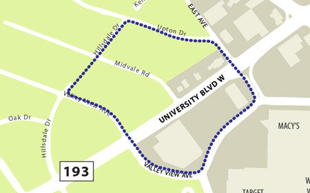
- Takes you on a tour of a quiet residential area of western Wheaton.
- Start at the corner of Valley View Avenue and Shopping Center Ring Road and work your way across University Blvd. (MD-193) into and around the Hillsdale Drive residential community.
- Approximate distance = 3610 feel or .7 miles Estimated time = 15—20 minutes
Marathon at the Mall
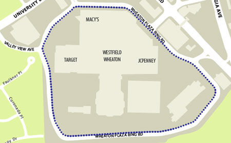
- This route will really get you going!
- Makes a full loop around the Westfield Shopping Center along Shopping Center Ring Road
- Approximate Distance = 5660 feet or 1.1 miles
- Estimated time = 20—30 minutes
Veirs Mill Stretch-It-Out
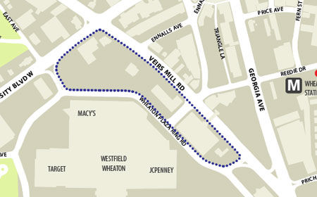
- Start on the Westfield Shopping Center side of the corner of Veirs Mill Road and University Blvd. and head south down Veirs Mill until you reach the Mall entrance. Head back up Shopping Center Ring Road until you reach University Blvd., make another right and you’re back at the start!
- Approximate distance = 4000 feet or 3/4 mile
- Estimated time = 15—20 minutes
Triangle Challenge
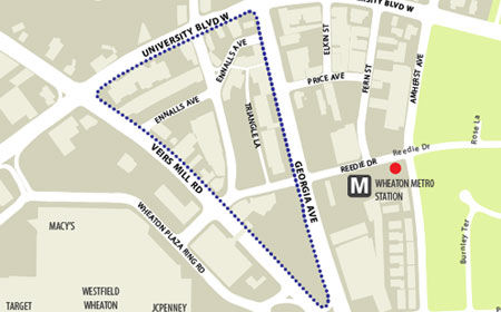
- This route takes you around all three sides of the widely-known Wheaton Triangle. Start at the corner of Veirs Mill Road and University Blvd. heading south towards Georgia Avenue. Once you reach Georgia Avenue, turn and head north back towards University Blvd. Finish up by walking west on University Blvd. back to the starting point!
- Approximate distance = 4625 feet or .9 miles
- Estimated time = 20—25 minutes
Little Amherst
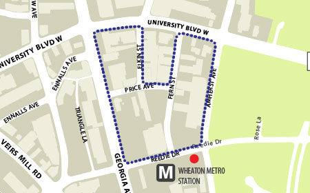
- Take this route around Reedie Drive and Amherst Avenue to make a giant “U” shape!
- Start at the corner of Reedie Drive and Georgia Avenue and head north up Georgia. Take a right and head east on University Blvd. until you reach Elkin Street.
- Take a right down Elkin, then make a left onto Price Avenue and walk up and make a left onto Fern Street to head back to University Blvd. Take University Blvd further east to Amherst Avenue. Walk down Amherst to get back to Reedie Drive and you’re done!
- Approximate distance = 4277 or .8 miles
- Estimated time = 15—20 minutes